Temple Site in Janghang-ri, Gyeongju
慶州 獐項里 寺址
경상북도 경주시
Basic information
- Designation
- Historic Site No.45
- Category
- 유적지
- Era
- 통일신라시대
- Designated year
- 1963
- Location
- 경주시, 경상북도— 경북 경주시 양북면 장항리 1081번지
- Coordinates
- 35.774956, 129.372924
AI Docent
Coming soonAn AI-generated, friendly retelling of this heritage site is available in Korean. An English version is on our roadmap — for now, please see the official description below.
Description
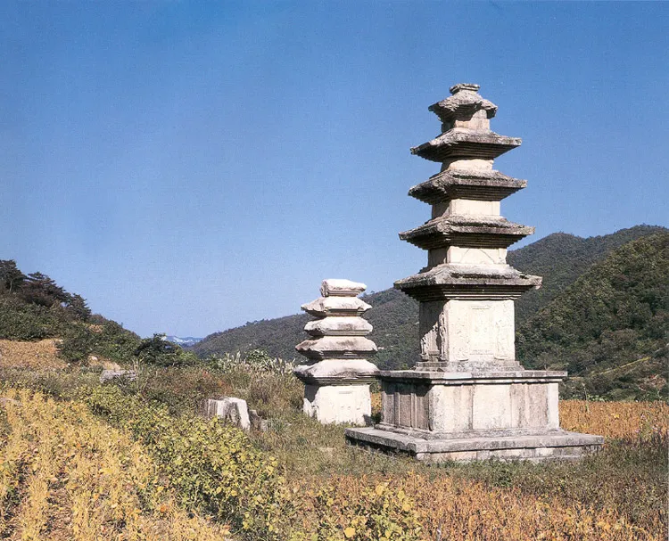
A Buddhist temple of the Unified Silla (668~935) once stood here, southeast of the summit of Tohamsan Mountain, as evidenced by two pagodas. A valley near the temple site is the upper stream of Daejongcheon that flows to the east sea. Neither the construction date nor the name of the temple is known, but this temple site is named Janghangnisaji after the town, Janghang-ri. The temple grounds appear to have been rather small. The main hall stood on a foundation, and some stones used in the foundation and the stairs in front of the main hall remain. Judging from the number of square corner stones, the hall is believed to have been 3kan wide and 3kan deep (kan is a traditional unit of measurement referring to the space between two columns). At the center of the main hall is a two-tiered pedestal for an image of Buddha. Buddhist guardians and beasts are carved on the sides of the octagonal lower part 60cm high and 2.4m at the widest part. The round upper part has height of 53cm and diameter of 1.84m. Lotus flowers adorn the upper part. The West Pagoda, about 15m from the site of the main hall, was restored in 1932 after it was blown up by relic robbers. Some stones from the East Pagoda, which were found scattered along a nearby valley, were brought here. The two pagodas are believed to have been of the same type and size. The image in the main hall was presumably a standing stone Buddha more than 4m high. Its fragments were taken to Gyeongju National Museum during the restoration of the West Pagoda in 1932. Noteworthy are the election of two pagodas and placement of the main hall at the center of the back in this small area between the valleys. The two pagodas are typical of the Unified Silla pagodas. The sites of an auditorium and an ambulatory were not recovered, however.
Location
지도를 불러오는 중…
Have you visited this place?
Log in and verify your visit on-site via GPS to record a stamp in My Journey. (QR verification coming later.)
Images: KOGL (khs.go.kr) · Data source: Korea Heritage Service Open API (khs.go.kr)