Gwanmunseong Fortress
關門城
경상북도 경주시
Basic information
- Designation
- Historic Site No.48
- Category
- Sites & Pagodas
- Era
- 통일신라 성덕왕
- Designated year
- 1963
- Location
- 경주시, 경상북도— 경북 경주시 외동읍 산업로 1739-6, 울산 북구 달천동,중산동,천곡동및 범서면 (모화리)
- Coordinates
- 35.662851, 129.328831
AI Docent
Coming soonAn AI-generated, friendly retelling of this heritage site is available in Korean. An English version is on our roadmap — for now, please see the official description below.
Description
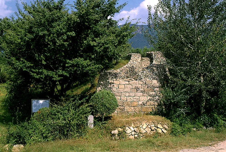
This fortress was built in 722, the 21st year of the reign of King Seongdeok, to protect the Silla capital of Gyeongju from enemies coming from the southeast. Formerly called Mobeolgunseong or Mobeolgwanmun, it was renamed Gwanmunseong during the Joseon Dynasty (1392-1910). This fortress and the Bukhyeongsanseong Fortress, built in 673, contributed to the defense of the east side. The total length is about 12km, which is why the local people call it Mallijangseong meaning “10,000 ri-long Wall.” ri is a traditional unit of measurement. Within the fortress, the sites of the gate, buildings, and warehouses remain. The fortress is composed of 40-50cm long stones piled in the running bond method of wall construction, i.e., wider at the base and narrowing gradually to reach a height of 4-5m. Gwanmunseong is different from other fortresses in Gyeongju in terms of construction, connecting mountains.
Location
지도를 불러오는 중…
Have you visited this place?
Log in and verify your visit on-site via GPS to record a stamp in My Journey. (QR verification coming later.)
Images: KOGL (khs.go.kr) · Data source: Korea Heritage Service Open API (khs.go.kr)