Gyeongjueupseong Walled Town
慶州邑城
경상북도 경주시
Basic information
- Designation
- Historic Site No.96
- Category
- Sites & Pagodas
- Era
- 1378년(고려 우왕 4년) 개축
- Designated year
- 1963
- Location
- 경주시, 경상북도— 경북 경주시 북부동 1번지
- Coordinates
- 35.847261, 129.213619
AI Docent
Coming soonAn AI-generated, friendly retelling of this heritage site is available in Korean. An English version is on our roadmap — for now, please see the official description below.
Description
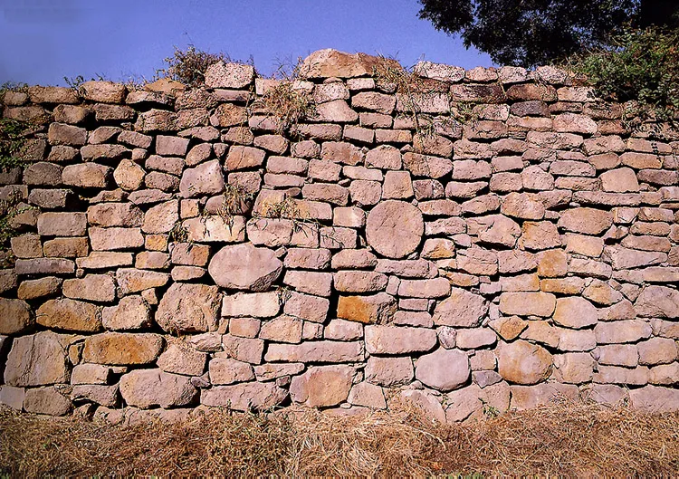
Gyeongju was the central city governing Silla. A city fortress wall (eupseong) was built mainly in the central local area, so Gyeongju naturally has a city fortress wall; it is not exactly known when it was built, however. According to Donggyeongtongji written by Jeong Inbo and Choe Namseon, which says it was reconstructed in the fourth year of the reign of King U of the Goryeo Dynasty (1378); therefore, historians simply assume that it was built before the record. The present city fortress wall was rebuilt in the early Joseon Dynasty; during the Japanese Aggression in 1592, however, it was burnt down. Thus, in the tenth year of the reign of King Injo in Joseon, it was reconstructed while making the western and the northern gates. As to the scale, there is a record stating that the circumference is 1.2km and the height is about 4m. There is a gate spanning all four sides for coming in and out. At present, there is no trace of the gates has been found. Since Gyeongju was enlarged due to city planning, most of the wall was torn down; today, about 50m of the eastern wall just remains in original form. The Bell of King Seongdeok the Great, kept in the Gyeongju National Museum, was hung in the gate of Jingnyemun, which was one of the four gates; thus, people were able to tell the time when the bell rang.
Location
지도를 불러오는 중…
Have you visited this place?
Log in and verify your visit on-site via GPS to record a stamp in My Journey. (QR verification coming later.)
Images: KOGL (khs.go.kr) · Data source: Korea Heritage Service Open API (khs.go.kr)