Najueupseong Walled Town
羅州邑城
전라남도 나주시
Basic information
- Designation
- Historic Site No.337
- Category
- Sites & Pagodas
- Designated year
- 1990
- Location
- 나주시, 전라남도— 전남 나주시 남내동 2-20번지 외
- Coordinates
- 35.034305, 126.717905
AI Docent
Coming soonAn AI-generated, friendly retelling of this heritage site is available in Korean. An English version is on our roadmap — for now, please see the official description below.
Description
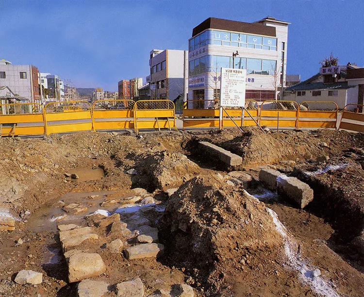
Najueupseong Walled Town was built in the Goryeo era, expanded in the 3rd year of the reign of King Sejo at the beginning of the Joseon Dynasty, and repaired on a large scale after the Japanese Invasion of Korea in 1592. According to a report of the fortress, it was made by pilling rocks, and it had circumference of about 940m and height of 2.7m. It is said to have had 3 Poru (hole to hold up cannon) on the wall of the fortress and 20 wells. There were four fortress gates, one each in the east, west, south, and north; at present, however, all of them are gone, and only the base stone at the north gate site remain. Namgomun Gate was restored at the site of the south gate in 1993; the two-storied small pavilion has 3 front boards and 2 side boards. Its showy roof shows part of the old appearance of Najueupseong. Only a few stone axes of the site of the south gate are left, but these important ruins should be preserved for their historical significance.
Location
지도를 불러오는 중…
Have you visited this place?
Log in and verify your visit on-site via GPS to record a stamp in My Journey. (QR verification coming later.)
Images: KOGL (khs.go.kr) · Data source: Korea Heritage Service Open API (khs.go.kr)