Dangposeong Fortress, Yeoncheon
漣川 堂浦城
경기도 연천군
Basic information
- Designation
- Historic Site No.468
- Category
- Sites & Pagodas
- Designated year
- 2006
- Location
- 연천군, 경기도— 경기 연천군 미산면 동이리 778 등
- Coordinates
- 38.023493, 126.985427
AI Docent
Coming soonAn AI-generated, friendly retelling of this heritage site is available in Korean. An English version is on our roadmap — for now, please see the official description below.
Description
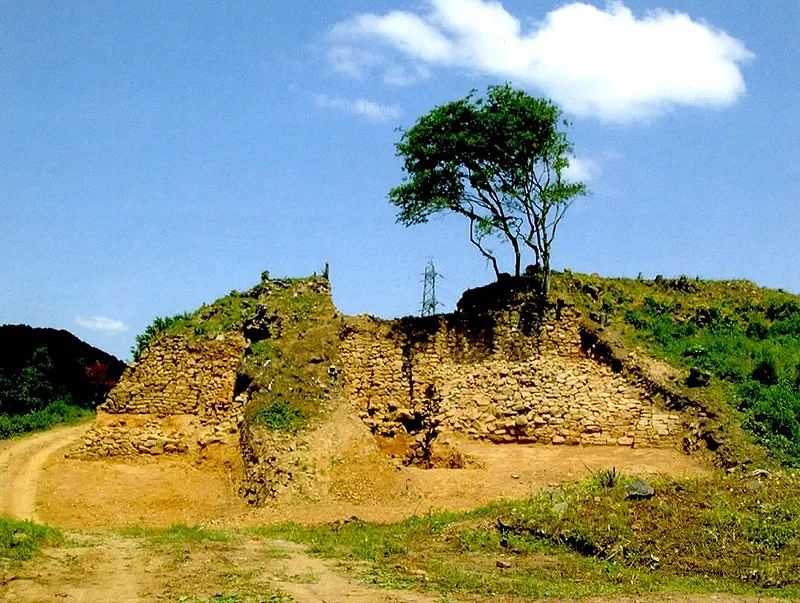
In various geography books of the Joseon Dynasty, there is no mention of Dangposeong Fortress except in Gieon byeoljip (Collection of Heo Mok's Writings) by Heo Mok: “There was an old fortress on the riverbank in front of the hemp fields. Above it was a shrine, and the ferry landing in front was called Dangpo. There are a big well and several channels for the water to flow out.” Between 1995 and 2003, surface survey and excavations were carried out, uncovering some Goguryeo earthenware; thus leading to the assumption that the fortress was made by Goguryeo in the Three Kingdoms Period. Dangposeong is a fortress built on flat land, making use of the natural cliff formed by the northwestern tributary of Imjingang River in Jeongok-eup. It is triangular in shape, with the western end forming a point; for this reason, the east wall is very high, whereas the remaining walls built along the cliff are low. The fortress is similar to nearby Horogoru Embankment and Eundaeriseong Fortress in terms of overall shape and is particularly like Horogoru in terms of method of construction. The section from the end of the west wall to the east wall measures 200m; the east wall measures 50m, and the entire circumference is approximately 450m. The remaining parts include 6m of the east wall and another 39m section. To get inside the fortress, part of the wall at the southern end of the east wall has been destroyed to make an entrance, and the northern end was torn down during the construction of a trench. Along with Yeoncheon’s Horogoru Embankment (Historic Site No. 467) and Eundaeriseong Fortress (Historic Site No. 469), Dangposeong is a unique riverside flatland fortress located on a triangular piece of land formed where the Imjingang and Hantangang rivers meet. It was vital during the Three Kingdoms Period when the Imjingang served as a water boundary; hence its considerable academic importance as a cultural relic.
Location
지도를 불러오는 중…
Have you visited this place?
Log in and verify your visit on-site via GPS to record a stamp in My Journey. (QR verification coming later.)
Images: KOGL (khs.go.kr) · Data source: Korea Heritage Service Open API (khs.go.kr)