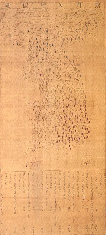
Joseon bangyeok jido (Map of the Korean Territory)
朝鮮方域之圖
경기도 과천시
Basic information
- Designation
- National Treasure No.248
- Category
- Painting
- Era
- 조선 명종 12년(1557)
- Designated year
- 1989
- Location
- 과천시, 경기도— 경기 과천시 교육원로 86, 국사편찬위원회 (중앙동,국사편찬위원회)
- Coordinates
- 37.424163, 126.979696
AI Docent
Coming soonAn AI-generated, friendly retelling of this heritage site is available in Korean. An English version is on our roadmap — for now, please see the official description below.
Description
This is a map of Korea made in the first half of the Joseon Dynasty. It is 61cm wide and 132cm long. Supposedly the map was made between 1557 and 1558. It was smuggled out into Japan during the Japanese Invasion of Korea in 1592 and was kept in Tsushima Island. It was brought back into Korea in the 1930s. The map consists of three columns. At the very top the title Joseon bangyeok jido is written. In the middle column, there is the map and in the third column the names, status of people associated in the making of the map is written. The locations of “ju” and “hyeon”, the administrative divisions of Joseon, major naval and army bases are marked on the eight “do”. Each “gun” and “hyeon” is marked in a different color for easy recognition. The borderlines between mountains and rivers are drawn in detail. Manchuria and Tsushima Island are included in the territory of Joseon, which shows that the people of the early Joseon Dynasty were conscious of their territorial rights. This is the only original map made under government support that remains from the early Joseon Dynasty. It is all the more significant for it gives valuable information on the development of map production in this period. Also, because this map has a lucid production date, it serves as a material for clarifying the production dates of other maps.
Location
지도를 불러오는 중…
Have you visited this place?
Log in and verify your visit on-site via GPS to record a stamp in My Journey. (QR verification coming later.)
Images: KOGL (khs.go.kr) · Data source: Korea Heritage Service Open API (khs.go.kr)