Gwanbugyeojido
關北輿地圖
부산광역시 서구
Basic information
- Designation
- Treasure No.2061
- Category
- Craft
- Era
- 1738년(영조 14)~1753년(영조 31) 사이
- Designated year
- 2020
- Location
- 서구, 부산광역시— 부산광역시 서구 구덕로 225 (부민동2가, 동아대학교부민캠퍼스)
- Coordinates
- 35.103741, 129.019415Kakao address conversion
AI Docent
Coming soonAn AI-generated, friendly retelling of this heritage site is available in Korean. An English version is on our roadmap — for now, please see the official description below.
Description
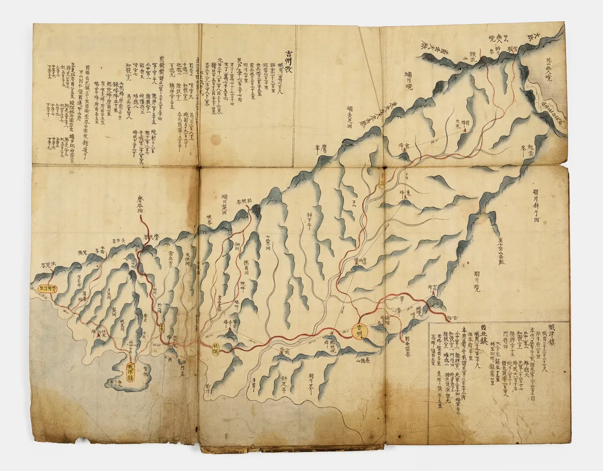
Gwanbukyeojido is a map of Gwanbuk province that is thought to have been made sometime between 1738 (the 14th year of the reign of King Yeongjo) and 1753 (the 31st year of the reign of King Yeongjo), judging by the way the geographical locations are marked. Notably, it marks the villages and strategic locations in Gwanbuk (present-day Hamgyeong-do Province) during the Joseon period. The map marks each myeon (local administrative unit) in detail, and the margin of each page is filled and includes a wealth of information such as how far this region is from the capital, the number of households, the number of troops, dwellings, and so on. The atlas also contains various clues as to when it was made, such as the results of a census taken in 1678 (the 4th year of the reign of King Sukjong), the location of Musanjin, a defensive position controlled by a local military commander, which was upgraded to ‘Dohobu’ in 1684 (the 10th year of the reign of King Sukjong), and the locations of border stone monuments erected in 1712. Perhaps the most noticeable feature of the atlas is the use of a line to mark the range of communication between beacon mounds, which is not marked on any other maps of the province or those of other provinces. It also marks the distance between each beacon mound for users’ convenience. The painting techniques, including the use of gorgeous colors and a three-dimensional effect to depict mountains and rivers, are so good that it would not be an exaggeration to say that it compares favorably with maps made by the Dohwaseo (Royal Bureau of Painting). Gwanbukyeojido is judged to be one of the best-preserved and most complete of all the local maps showing the defensive positions of the country’s northern provinces. In addition, it distinguishes Gwanbuk (present-day Hamgyeong-do Province) from the areas controlled by outsiders, and marks the distance between the beacon mounds, and the method of sending signals via beacon fire in detail. As such, it can be said to be a groundbreaking document in the history of cartography in Korea.
Location
지도를 불러오는 중…
Have you visited this place?
Log in and verify your visit on-site via GPS to record a stamp in My Journey. (QR verification coming later.)
Images: KOGL (khs.go.kr) · Data source: Korea Heritage Service Open API (khs.go.kr)