Yeojidoseo
輿地圖書
서울특별시 중구
Basic information
- Designation
- Treasure No.2249
- Category
- Books & Records
- Era
- 1757년(조선 영조 33)∼1765년(조선 영조 41)
- Designated year
- 2024
- Location
- 중구, 서울특별시— 서울특별시 중구 삼일대로 330 (저동1가, 평화빌딩) 4층, 한국교회사연구소
- Coordinates
- 37.564383, 126.988433Kakao address conversion
AI Docent
Coming soonAn AI-generated, friendly retelling of this heritage site is available in Korean. An English version is on our roadmap — for now, please see the official description below.
Description
Machine-translatedThis English description was machine-translated and may contain inaccuracies. Refer to the original Korean text for details.
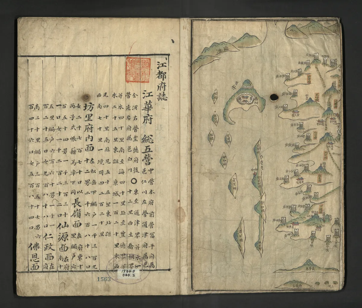
The 'Geography and Maps of Joseon' (輿地圖書), housed at the Korea Church Historical Research Institute, represents an official geographical gazetteer compiled during the late Joseon period when emerging social transformations necessitated comprehensive reference materials for efficient provincial administration. Materials compiled by individual counties and municipalities during the King Yeongjo era were collected through provincial capitals for final compilation, resulting in unified records with diverse characteristics reflecting local variations. The compilation dates for each county-municipal record are estimated around the 1760s, with content regarding household registers and field assessments appearing to reference the 'Gimyo Registers' (己卯帳籍) compiled in 1759 (King Yeongjo 35). Comprising 55 bound volumes containing 295 county-municipal gazetteers, 17 provincial-capital gazetteers, and 1 garrison gazetteer. The cover displays both the title 'Geography and Maps of Joseon' and the recorded counties-municipalities, with the main content featuring maps and geographical descriptions. Unlike previous gazetteers, the 'Geography and Maps of Joseon' attached maps preceding each county-municipal entry. These color-painted manuscript maps cover 1-2 pages, including color provincial maps for six provinces excluding Gyeonggi and Jeolla provinces, 12 provincial-capital and garrison maps, and 296 county-municipal maps. While map drawing formats, composition methods, and coloration vary among counties, distances and bearings remain comparatively accurate. Geographical descriptions are written on 10-line gridded pages, with some featuring red gridlines. Content encompasses approximately 38 categories including territory (疆域), neighborhoods (坊里), establishment-and-revision history (建置年革), county names (郡名), mountains and rivers (山川), family names (姓氏), customs (風俗), warehouses (倉庫), and local products (物産), expanded from previous gazetteer categories. Notably, socio-economic content items were added including household registers, roads, dikes, pastures, dry fields, and wet fields. The 'Geography and Maps of Joseon' represents the first integrated example combining county-municipal maps with gazetteers, subsequently serving as the basis for 1872 regional map production and 19th-century gazetteer compilation, holding historical value. Containing both territorial space maps and history-culture-society-economy content, it serves as essential reference material for late Joseon socio-economic history and historical geography research. Additionally, as the sole surviving copy with the original 55-volume binding substantially preserved, it possesses both rarity and completeness.
Location
지도를 불러오는 중…
Have you visited this place?
Log in and verify your visit on-site via GPS to record a stamp in My Journey. (QR verification coming later.)
Images: KOGL (khs.go.kr) · Data source: Korea Heritage Service Open API (khs.go.kr)