Haedongpaldobonghwasanakjido
海東八道烽火山岳地圖
서울특별시 성북구
Basic information
- Designation
- Treasure No.1533
- Category
- Craft
- Era
- 17세기 후반
- Designated year
- 2007
- Location
- 성북구, 서울특별시— 서울 성북구 안암로 145, 중앙도서관 (안암동5가,고려대학교안암캠퍼스(인문사회계))
- Coordinates
- 37.588703, 127.031698Kakao address conversion
AI Docent
Coming soonAn AI-generated, friendly retelling of this heritage site is available in Korean. An English version is on our roadmap — for now, please see the official description below.
Description
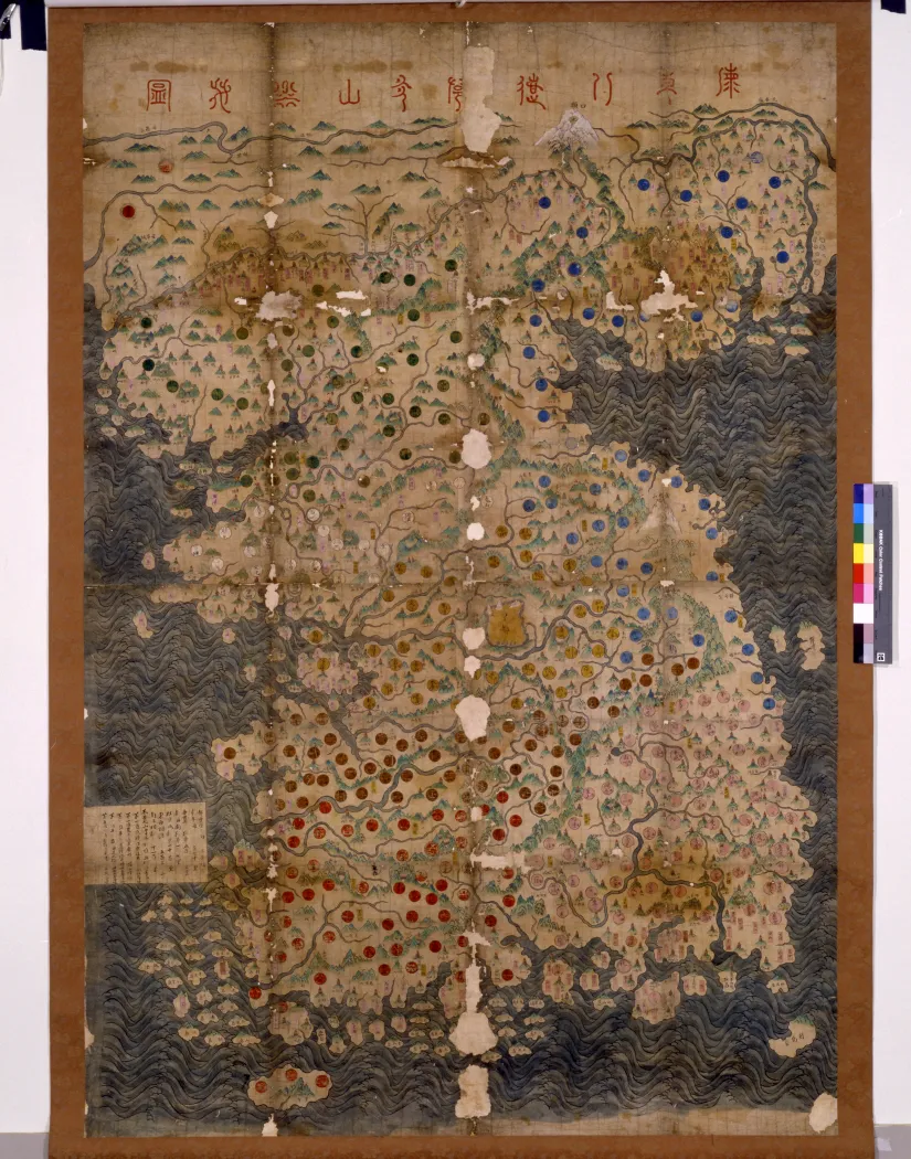
With a title written in seal script along the upper edge, the map shows the locations of beacon mounds across Korea, along with administrative towns, mountain peaks and ranges and waterways, as well as the seas and islands surrounding the country. The beacon mounds, a great majority of them concentrated in the northern border areas along the Amnokgang and Dumangang Rivers and the Gyeongsang-do area in the south, are marked with figures resembling candlelight above mountain tops. Geographical names are written within circles of various colors, including white, red, yellow, brown, green and blue, representing different regions. The map has outstanding historical value in that it shows routes of beacon communication during the Joseon Dynasty. It is also notable for its remarkable painterly quality; the mountain ridges are effectively depicted with brush lines and bluish-green pigment, and the waves are carefully rendered in interesting shapes comprised of fine parallel lines in grayish-blue, exuding a sense of dynamic movement. It is also particularly noteworthy that Baekdusan Mountain, regarded as the origin of the mountain ranges stretching over the Korean Peninsula, is emphatically rendered in white pigment. Geumgangsan Mountain is also depicted in a similar manner. Considering that the map shows Gimcheon, created in 1652 by merging Gangeum and Ubong in Hwanghae-do Province, but not the border stele on Baekdusan Mountain, erected in 1712, the map is assumed to have been made sometime around the latter half of the 17th century. It is impressive not only for its historical and artistic value but also its remarkable scale, measuring nearly two meters in length.
Location
지도를 불러오는 중…
Have you visited this place?
Log in and verify your visit on-site via GPS to record a stamp in My Journey. (QR verification coming later.)
Images: KOGL (khs.go.kr) · Data source: Korea Heritage Service Open API (khs.go.kr)