Sukbinchoessi Soryeongwondo
淑嬪崔氏 昭寧園圖
경기도 성남시
Basic information
- Designation
- Treasure No.1535
- Category
- Craft
- Era
- 18세기
- Designated year
- 2007
- Location
- 성남시, 경기도— 경기도 성남시 분당구 하오개로 323 (운중동, 한국학중앙연구원)
- Coordinates
- 37.393030, 127.052183
AI Docent
Coming soonAn AI-generated, friendly retelling of this heritage site is available in Korean. An English version is on our roadmap — for now, please see the official description below.
Description
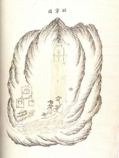
Soryeongwondo depicts the Tomb of Royal Lady Choe (1670-1718), a concubine of King Sukjong and the birth mother of King Yeongjo. When she died in 1718 (the 44th year of King Sukjong’sreign), Lady Choe was buried in Ongjang-ri, Goryeong-dong, Yangju, which is present-day Gwangtan-myeon, Paju, Gyeonggi-do. Her burial site was endowed the status of second-grade royal graveyard and named Soryeongwon, meaning the “Garden of Bright Peace,” in 1753 (the 29th year of King Yeongjo’s reign). “Myoso dohyeong yeo salon (Tomb Map and Geomantic Explanation)” is a thick sheet of paper with a drawing of Lady Choe’s burial site and its topographical surroundings at the center and a brief explanation of the site selection at the bottom. This is probably an original work made in 1718, in the process of choosing a propitious burial site following her death, while the following three maps are assumed to have been made in the late 18th century after her tomb was promoted in status. “Soryeongwon do (Map of Soryeongwon),” in the typical style of a royal graveyard map, depicts the burial area at the center with a ritual hall at left, a stele pavilion at right, and farmland and paddies toward the bottom. The landscape is depicted with long hemp-fiber strokes and dots, with light color washes applied here and there. “Soryeongwon hwaso jeonggyedo (Map for Fire-Prevention Forest Removal at Soryeongwon)” shows the borderline for burning trees and grass around the burial ground to keep wildfire from spreading. The borderline is marked in red. Overall the map is in the typical mountain map style with the landscape roughly depicted in rapid hemp-fiber strokes. “Soryeongwon baechido (Layout Map of Soryeongwon)” shows the arrangement of stone sculptures depicted with a simple outline technique. It shows the actual positions of the bent wall at the back of the burial mound, a tomb stone, stone altar for the spirit of the dead, a table, a lantern, two pillars and stone figures of civil officials. All these four painting-style maps, drawn on fine mulberry paper, are important resources concerning the royal tombs of the Joseon Dynasty.
Location
지도를 불러오는 중…
Have you visited this place?
Log in and verify your visit on-site via GPS to record a stamp in My Journey. (QR verification coming later.)
Images: KOGL (khs.go.kr) · Data source: Korea Heritage Service Open API (khs.go.kr)