Seobukpiayanggyemanriilramjido(2008)
西北彼我兩界萬里一覽之圖(2008)
서울특별시 관악구
Basic information
- Designation
- Treasure No.1537-2
- Category
- Craft
- Era
- 18세기
- Designated year
- 2008
- Location
- 관악구, 서울특별시— 서울 관악구 관악로 1,103동 서울대학교 규장각한국학연구원 (신림동,서울대학교)
- Coordinates
- 37.462351, 126.950453
AI Docent
Coming soonAn AI-generated, friendly retelling of this heritage site is available in Korean. An English version is on our roadmap — for now, please see the official description below.
Description
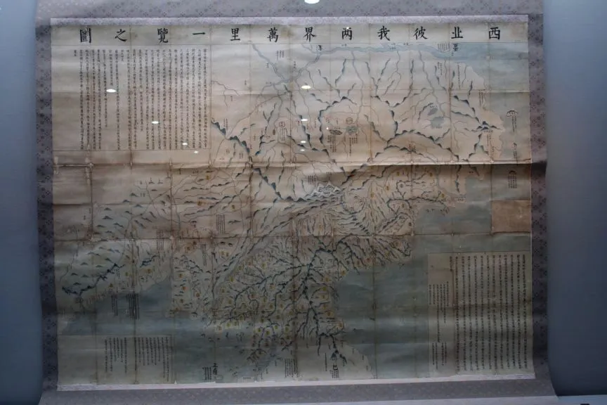
This is one of the most notable frontier maps produced in late Joseon. It marks in detail transportation networks and sites of military importance around the Amnokgang and Dumangang Rivers dividing Korea and China. The inscription gives the history of Manchuria, noting that the region had been Korean territory and that Shenyang, Liaoyang and Jianzhou were renamed Shengjing, Dongjing and Xingjing, respectively, under the Qing Dynasty. The map shows in particular the route from Uiju to Shanhaiguan, along with waterways, mountains and mountain ranges and administrative counties in northern Korean provinces as well as roads and major transportation and military hubs in border regions. Manchuria is not depicted in such great detail, but segments of the Great Wall and wooden walls are presented. The road connecting Uiju in Korea to Fenghuangcheng, Shengjing and Shanhaiguan is presented with gateways, stations and small fortresses on the way. The road from Hoeryeong and Gyeongwon in northeastern Korea to Ningguta and Kaiyuan is also clearly marked.
Location
지도를 불러오는 중…
Have you visited this place?
Log in and verify your visit on-site via GPS to record a stamp in My Journey. (QR verification coming later.)
Images: KOGL (khs.go.kr) · Data source: Korea Heritage Service Open API (khs.go.kr)