Jeonjujido
全州地圖
서울특별시 관악구
Basic information
- Designation
- Treasure No.1586
- Category
- Craft
- Era
- 18세기
- Designated year
- 2008
- Location
- 관악구, 서울특별시— 서울 관악구 관악로 1,103동 서울대학교 규장각한국학연구원 (신림동,서울대학교)
- Coordinates
- 37.462351, 126.950453
AI Docent
Coming soonAn AI-generated, friendly retelling of this heritage site is available in Korean. An English version is on our roadmap — for now, please see the official description below.
Description
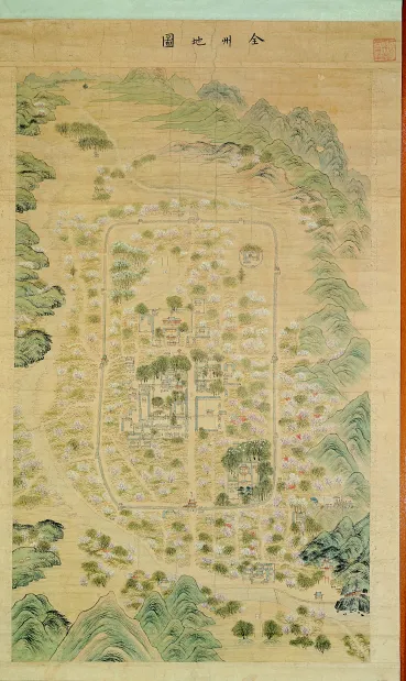
Actively employing elements of landscape painting, this map offers a bird’s-eye view of the walled city of Jeonju encircled by a series of mountain peaks. Within the city wall, houses are clustered along grid roads and bright peach flowers are in full bloom all around. It is noteworthy that Jogyeongmyo Shrine, a temple erected in 1771 to honor the founding ancestor of the royal family of the Joseon Dynasty, is not presented on the grounds of Gyeonggijeon Shrine. Instead, the grounds of the Jogyeongmyo are depicted with many trees and herons, emphasizing an auspicious ambience. Houses and government buildings are precisely depicted in rather thin ink lines. The landscape clearly reflects influences from the true view style of Jeong Seon (1676-1759), but buildings and human figures tend to follow the painting style after the late 18th century. In particular, they show similarities to court paintings documenting palace banquets and ceremonial events. In view of the refined composition, skillful brushwork and dignified style, the map is believed to have been made by a painter who received formal art education in the capital city. This is one of the most outstanding painting-style maps produced during the Joseon Period.
Location
지도를 불러오는 중…
Have you visited this place?
Log in and verify your visit on-site via GPS to record a stamp in My Journey. (QR verification coming later.)
Images: KOGL (khs.go.kr) · Data source: Korea Heritage Service Open API (khs.go.kr)