Hwadonggojido
華東古地圖
서울특별시 관악구
Basic information
- Designation
- Treasure No.1590
- Category
- Craft
- Era
- 16세기
- Designated year
- 2008
- Location
- 관악구, 서울특별시— 서울 관악구 관악로 1,103동 서울대학교 규장각한국학연구원 (신림동,서울대학교)
- Coordinates
- 37.462351, 126.950453
AI Docent
Coming soonAn AI-generated, friendly retelling of this heritage site is available in Korean. An English version is on our roadmap — for now, please see the official description below.
Description
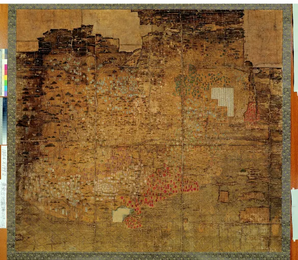
This map depicts China and Korea, with Japan merely indicated by its location. It resembles Honil gangni yeokdae gukdo jido (Integrated Map of Historical Capitals), but with greater focus on China and deleting Arabia. The map reflects the China-oriented global perspective, which emerged among Koreans in the 16th century. With the seas rendered in wave form, the map has similar contours of the Asian continent to the Integrated Map of Historical Capitals produced in 1402, with Korea depicted more precisely and in greater detail. Regrettably, however, the section for the Hamgyeong-do Region has been severely abraded with the county names obliterated and Baekdusan Mountain also blurred. Korean provinces and counties are marked in different base colors from those of China. Toward the bottom, in the Yellow Sea south of the Shandong Peninsula, is found a record on the changing courses of the Yellow River through history. The map was made before the Japanese Invasions of 1592-1598. It is rare and valuable cartographic material from the early Joseon Dynasty, which offers a glimpse of the 16th-century world view of Koreans.
Location
지도를 불러오는 중…
Have you visited this place?
Log in and verify your visit on-site via GPS to record a stamp in My Journey. (QR verification coming later.)
Images: KOGL (khs.go.kr) · Data source: Korea Heritage Service Open API (khs.go.kr)