Agugyeojido
俄國輿地圖
경기도 성남시
Basic information
- Designation
- Treasure No.1597
- Category
- Craft
- Era
- 19세기
- Designated year
- 2008
- Location
- 성남시, 경기도— 경기도 성남시 분당구 하오개로 323 (운중동, 한국학중앙연구원)
- Coordinates
- 37.393030, 127.052183
AI Docent
Coming soonAn AI-generated, friendly retelling of this heritage site is available in Korean. An English version is on our roadmap — for now, please see the official description below.
Description
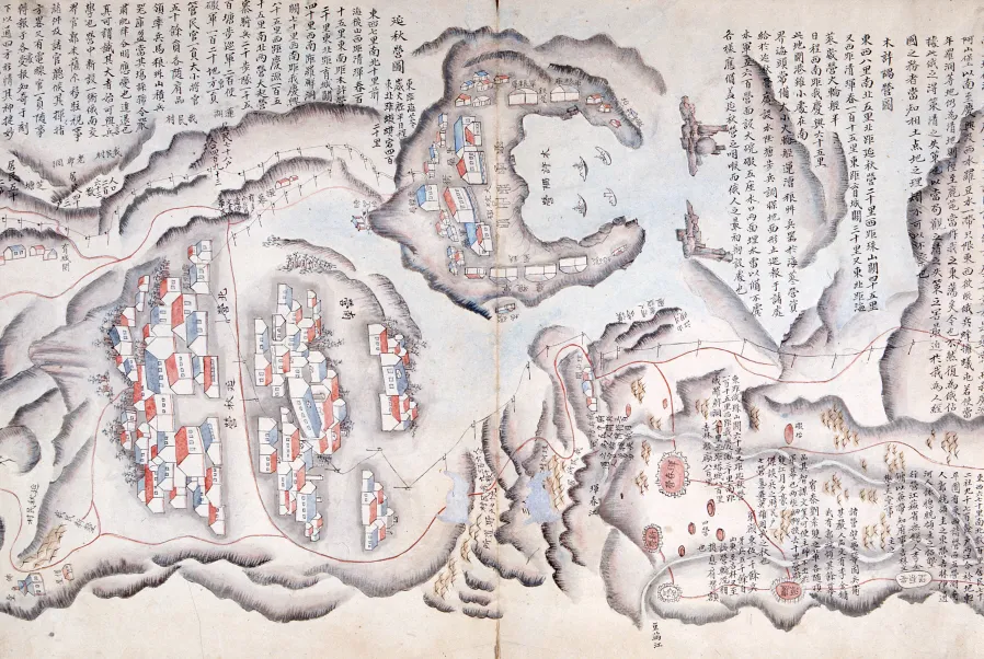
This is a 20-page folding album carrying a large map of northeastern border regions, reaching three meters when spread out. The front page has a table of contents, and the maps present the number of households, population, produce, military relations and geographic distances of various regions. At the end is a paper on the Cheonga yeojihyeong jeongseok uiseo (Detailed Topography of Qing and Korean Sides and Situation Analysis), jointly written by Kim Gwang-hun and Sin Seon-uk. Drawn in ink and color on high-quality Western paper, the painting-like map depicts Hamgyeong-do Province and the Russian Far East in the typical frontier map style. The two mapmakers, Kim Gwang-hun and Sin Seon-uk, surveyed the border areas over 16 years for this project, but it is not known when they completed the map. It can only be assumed that the map was made between 1885 and 1905. It is valuable material for the study of border conflicts among Joseon, Russia and Qing as well as the history of mapmaking and painting.
Location
지도를 불러오는 중…
Have you visited this place?
Log in and verify your visit on-site via GPS to record a stamp in My Journey. (QR verification coming later.)
Images: KOGL (khs.go.kr) · Data source: Korea Heritage Service Open API (khs.go.kr)