Joseonpaldogogeumchongramdo
朝鮮八道古今總覽圖
서울특별시 종로구
Basic information
- Designation
- Treasure No.1602
- Category
- Craft
- Era
- 1673년
- Designated year
- 2008
- Location
- 종로구, 서울특별시— 서울 종로구 새문안로 55, 서울역사박물관 (신문로2가,서울역사박물관)
- Coordinates
- 37.570149, 126.970429
AI Docent
Coming soonAn AI-generated, friendly retelling of this heritage site is available in Korean. An English version is on our roadmap — for now, please see the official description below.
Description
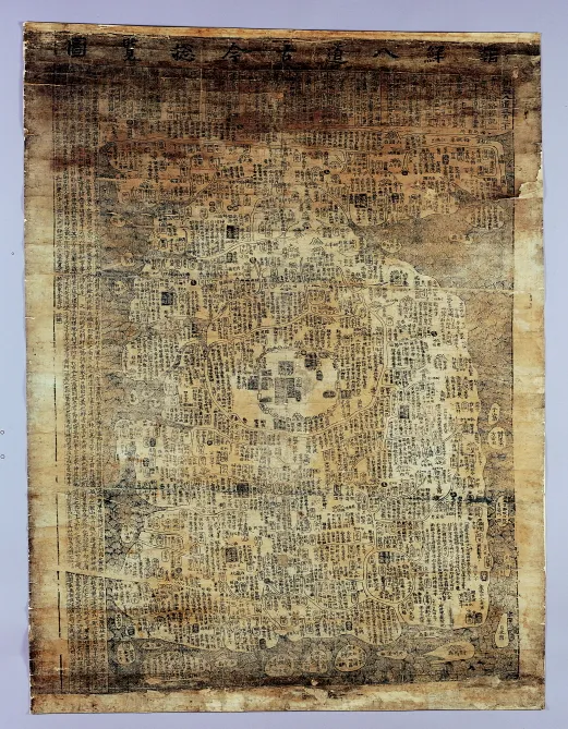
This woodblock print map of Korea records the local history of different regions, so it offers both geographic and historical knowledge about the country. The map was made by Kim Su-hong (1602-1681), the grandson of Kim Sang-yong who perished in battle in Ganghwado Island during the Manchu Invasion of 1636-1637. He once served as vice minister of taxation. The inscription along the left edge notes the map was made in the height of summer in the gyechuk year, which corresponds to 1673 (the 14th year of King Hyeonjong’s reign). In 1666 (the 7th year of King Hyeonjong’s reign), Kim had made Cheonha gogeum daechong pyeollamdo (Great World Map of Past and Present). Korea in this map is presented in its typical shape often found in other maps of the early Joseon Dynasty. The Amnokgang and Dumangang Rivers along the northern border are depicted on one horizontal line, with Pyeongan-do and Hamgyeong-do Provinces severely flattened. Seoul is depicted larger than scale, with Gyeongbokgung Palace, the State Council and the Six Ministries before Gwanghwamun Gate, as well as Nambyeolgung, or the Southern Royal Villa, which stood at the present site of Westin Chosun Hotel. With its unique content integrating geographic information with historical knowledge, the map is highly estimated for having explored new realms in cartography. Its historic and academic value is further heightened by clear indication of the production date and identity of the mapmaker.
Location
지도를 불러오는 중…
Have you visited this place?
Log in and verify your visit on-site via GPS to record a stamp in My Journey. (QR verification coming later.)
Images: KOGL (khs.go.kr) · Data source: Korea Heritage Service Open API (khs.go.kr)