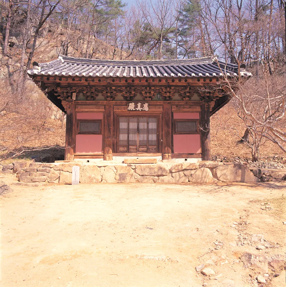
Buryeongsa Eungjin Hall, Uljin
蔚珍 佛影寺 應眞殿
경상북도 울진군
Basic information
- Designation
- Treasure No.730
- Category
- Architecture
- Era
- 조선시대
- Designated year
- 1981
- Location
- 울진군, 경상북도— 경상북도 울진군 불영사길 48 (금강송면, 불영사)
- Coordinates
- 36.941135, 129.273021
AI Docent
Coming soonAn AI-generated, friendly retelling of this heritage site is available in Korean. An English version is on our roadmap — for now, please see the official description below.
Description
Buryeongsa Temple was built by the great monk Uisang in 651 (the fifth year of the reign of Queen Jindeok of the Silla Dynasty). According to a legend, Uisang saw five Buddha images hovering above a pond in this area, drove out the dragons that inhabited them, and then built Buryeongsa Temple at the site. The temple was all but destroyed by fire, with the exception of Nahanjeon Hall, in 1396 (the fifth year of the reign of King Taejo of the Joseon Dynasty), and was burnt down again, this time with the exception of Yeongsanjeon Hall, during the Japanese Invasion of Korea in 1592. After several sets of reconstruction and restoration work, the temple acquired its present appearance. Eungjinjeon Hall enshrines Sakyamuni Buddha at the center, Anan on the left, Gaseop on the right and sixteen Arhat statues. According to a record found during repair work in 1984, the hall was rebuilt several times before and after the Japanese Invasion of Korea in 1592, and was originally called Yeongsanjeon Hall. The hall measures three kan (a unit of measurement referring to the distance between two columns) at the front and two kan at the sides, and has a gable roof resembling the letter 人 when viewed from the side. The eaves of the roof are supported by a system of decorated brackets placed on and between the pillars. Two pairs of sliding doors are installed in the middle of the front space, and there are small windows on the sides. The ceiling is decorated with patterns of the Chinese character ‘井' , which was designed to hide the inside of the ceiling. The building’s mid-Joseon dancheong patterns (traditional multi-colored paintwork on wooden buildings) have been well preserved.
Location
지도를 불러오는 중…
Have you visited this place?
Log in and verify your visit on-site via GPS to record a stamp in My Journey. (QR verification coming later.)
Images: KOGL (khs.go.kr) · Data source: Korea Heritage Service Open API (khs.go.kr)