Sageunsanseong Fortress, Hamyang
咸陽 沙斤山城
경상남도 함양군
Basic information
- Designation
- Historic Site No.152
- Category
- Sites & Pagodas
- Era
- 삼국시대
- Designated year
- 1966
- Location
- 함양군, 경상남도— 경남 함양군 수동면 원평리 산60번지
- Coordinates
- 35.534023, 127.793477
AI Docent
Coming soonAn AI-generated, friendly retelling of this heritage site is available in Korean. An English version is on our roadmap — for now, please see the official description below.
Description
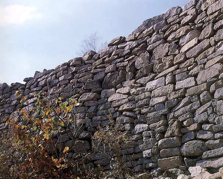
This fortress is located at Yeonhwasan Mountain behind the traditional marketplace of Hasan-ri, Hamyang-gun, Gyeongsangnam-do where Sageunyeok Station, the center of convergence of the 14 routes of Gyeongsang-do, used to stand. The exact construction date of the fortress is not known; from the scale of it and its location in the volatile area between Silla and Baekje, however, it is believed to have been built during the Three Kingdoms Period. In spite of some partial breaks, it is relatively well-preserved. With circumference of 500m, it was made by piling “ㅏ”-shaped stones along the ridgeline of Yeonhwasan Mountain. The wall of the fortress, which is really strong with its base measuring 5m wide, is made by piling polished square stones or unpolished stones. This fortress, surrounded by Namgang River in three directions, was a place of strategic importance bridging the Yeongnam region and Honam region and a barrier to prevent the Japanese pirates from invading the granary of the Honam region.
Location
지도를 불러오는 중…
Have you visited this place?
Log in and verify your visit on-site via GPS to record a stamp in My Journey. (QR verification coming later.)
Images: KOGL (khs.go.kr) · Data source: Korea Heritage Service Open API (khs.go.kr)