Marisan Tumuli, Haman
咸安 末伊山 古墳群
경상남도 함안군
Basic information
- Designation
- Historic Site No.515
- Category
- 유적지
- Designated year
- 2011
- Location
- 함안군, 경상남도— 경남 함안군 가야읍 도항리 484 등
- Coordinates
- 35.268979, 128.403003
AI Docent
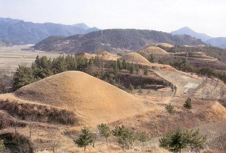
✨ AI-generatedWelcome to Marisan Tumuli in Haman! Imagine standing before 37 massive earthen mounds arranged in rows on elevated ground. These aren't random hills—they're believed to be the royal tombs of Ara Gaya kings, rulers of an ancient Korean kingdom. What makes this site extraordinary? These tumuli are genuinely massive. The largest measures nearly 40 meters across and almost 10 meters high—that's taller than a three-story building! When archaeologists excavated the 8th mound, they discovered the remains of five individuals, giving us rare glimpses into royal burial practices thousands of years ago. The site itself tells a story of preservation and recognition. Originally two separate groups, they were unified in 2011 because of their historical importance. Today, standing among these ancient monuments, you're walking through the landscape of Gaya's powerful past—a civilization that shaped Korean history long before the kingdoms you might know better.
⚠ This is an AI-generated retelling of the official description. For accuracy, refer to the official description below.
Description
Machine-translatedThis English description was machine-translated and may contain inaccuracies. Refer to the original Korean text for details.
The Haman Marisan Tumuli Group was originally separated into Haman Dohangli Tumuli and Haman Marisan-ri Tumuli, which were unified and redesignated as the Haman Marisan Tumuli Group on July 28, 2011, in consideration of historical characteristics. This tumuli group of 37 large tumuli, believed to be the tombs of Ara Gaya kings, is arranged in rows at elevated positions. The site was first investigated during the Japanese colonial period, when the then-designated 34th tumulus measured 39.3 meters in diameter and 9.7 meters in height, representing a large-scale tomb. Recent excavations of the 8th tumulus revealed the skeletal remains of five sacrificial burials.
Location
지도를 불러오는 중…
Have you visited this place?
Log in and verify your visit on-site via GPS to record a stamp in My Journey. (QR verification coming later.)
Images: KOGL (khs.go.kr) · Data source: Korea Heritage Service Open API (khs.go.kr)