Bukcheonsu Grove in Buksong-ri, Pohang
浦項 北松里 北川藪
경상북도 포항시
Basic information
- Designation
- Natural Monument No.468
- Category
- 동식물
- Era
- 수령 50~200여년
- Designated year
- 2006
- Location
- 포항시, 경상북도— 경북 포항시 북구 흥해읍 북송길 63 (북송리)
- Coordinates
- 36.117129, 129.323399
AI Docent
Coming soonAn AI-generated, friendly retelling of this heritage site is available in Korean. An English version is on our roadmap — for now, please see the official description below.
Description
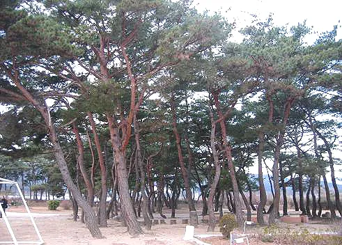
Bukcheonsu is a pine forest that stretches 2.5km along the Bukcheon Stream in Buksong-ri, Heunghae-eup, Pohang. The forest has been famous from the past and is mentioned in many old records. The name is mentioned in the Heunghaehyeon jido (map of Heunghaehyeon) owned by Kyujanggak, a record of how the forest was created in Hangukjimyeong chongnam (encyclopedia of geographical names of Korea), and a survey of the forest from 1938 in Joseonui imsu (report on forests of Korea). Today, it is the third-longest forest in Korea. Based on the record in Hangukjimyeong chongnam, the forest appears to have been created to prevent the flooding of Heunghae-eup and as windbreak: “Seeking to protect the town fortress and Doeumsan Mountain, the guardian mountain of Heunghae, and seeing that flooding occurred every summer because there were no banks along the stream, Yi Deuk-gang, magistrate of Heunghae-gun during the reign of King Cheoljong of Joseon, mobilized the local residents to build banks along Bukcheon Stream and plant a forest stretching for 4 ri (10km).” Moreover, it is a historically important forest as it is presumed to have been planted to create the ideal environment in terms of geomancy, with the forest in front and the mountain to the back. The forest also has great cultural value for its role in the practice of indigenous faiths. On the first full moon of the year, the villagers would hold a rite for the tutelary gods at an altar in the forest, with another rite for the mountain in front of the village held at 3 p.m. on the same day. As part of the rite, the fortune for the coming year would be told by inspecting the state of saltwater that had been kept buried in a bottle the year before. Therefore, Bukcheonsu Grove in Buksong-ri has been preserved well by the villagers for a long time.
Location
지도를 불러오는 중…
Have you visited this place?
Log in and verify your visit on-site via GPS to record a stamp in My Journey. (QR verification coming later.)
Images: KOGL (khs.go.kr) · Data source: Korea Heritage Service Open API (khs.go.kr)