Sin·gubeopcheonmundo
新·舊法天文圖
경기도 파주시
Basic information
- Designation
- Treasure No.1318
- Category
- Craft
- Era
- 조선시대(1720∼1730)
- Designated year
- 2001
- Location
- 파주시, 경기도— 경기도 파주시 헤이리로 30 (탄현면, 국립민속박물관 파주관)
- Coordinates
- 37.579800, 126.983100Museum-based location
AI Docent
Coming soonAn AI-generated, friendly retelling of this heritage site is available in Korean. An English version is on our roadmap — for now, please see the official description below.
Description
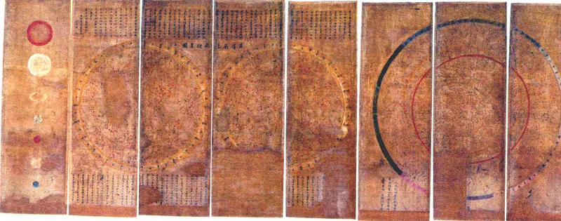
These used to be contained in an eight-part folding screen of Celestial Charts made on sheets of hanji (Korean traditional paper). The chart is composed of a 14th-century Korean star map (Cheonsang Yeolcha Bunyajido/National Treasure No. 228) and Folding Screen of Sinbeop cheonmundo at Beopjusa Temple, Boeun (a western celestial chart, Treasure No. 848) dating back to the 17th Century or thereafter. The first three parts of the folding screen used to contain the Cheonsang Yeolcha Bunyajido. The next four parts formerly had the western celestial chart. The last part used to contain a chart for the sun, the moon, and the five planets (the names of the five planets are marked in the traditional Korean way). Based on the way the five planets are named, this one is believed to have been made earlier (around the 1720s-1730s) than the western astronomical chart (planets are marked as Saturn, Titan, Mars, Venus, and Mercury). Two other copies of these celestial charts are kept at the Whipple Museum of the History of Science, University of Cambridge, and Namban Bunkakan Museum, Japan. Made by the Office for the Observance of Natural Phenomena, the celestial charts are a cultural heritage showing the country’s history of science as well as how Koreans viewed the universe in the early 18th Century.
Location
지도를 불러오는 중…
Have you visited this place?
Log in and verify your visit on-site via GPS to record a stamp in My Journey. (QR verification coming later.)
Images: KOGL (khs.go.kr) · Data source: Korea Heritage Service Open API (khs.go.kr)