Gonyeomangukjeondo
坤輿萬國全圖
서울특별시 관악구
Basic information
- Designation
- Treasure No.849
- Category
- Craft
- Era
- 조선시대
- Designated year
- 1985
- Location
- 관악구, 서울특별시— 서울 관악구 관악로 1, 박물관 (신림동,서울대학교)
- Coordinates
- 37.464530, 126.952267
AI Docent
Coming soonAn AI-generated, friendly retelling of this heritage site is available in Korean. An English version is on our roadmap — for now, please see the official description below.
Description
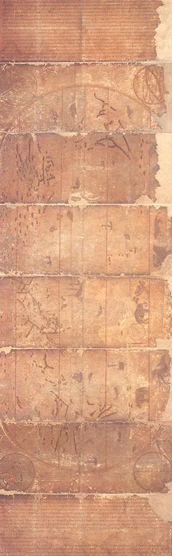
This beautifully colored world map, Gonyeo manguk jeondo, made during the Joseon Dynasty (1392-1910), is a hand-painted copy of the world atlas made by Mateo Ricci in 1602. It was brought to Korea in the 36th year of King Seonjo's reign (1603) by Yi Gwang-jeong and Gwon Hi, who had been dispatched to China. Until that time, a China-centered world map made in 1402, Honil gangnido, was the mainstream in the Joseon Dynasty. However, Gonyeo manguk jeondo introduced western geography to Korea, giving rise to the formation of new views of the world, and efforts were made to ensure the transmission of Korea's own outstanding scientific tradition. Five continents including Europe and Africa, 850-odd geographical designations and information on ethnicities and produce are recorded on the map. In 1708, the 34th year of the reign of King Sukjong (1674-1720), Yi Guk-chwe and Yu U-chang together with a famous painter of the time, Kim Jin-yeo, copied the six-fold oval atlas originally published as a woodblock print in China in 1602. The story of how the copy was made was written by Choe Seok-jeong. This map is considered to be the most excellent and beautiful world map made in the Joseon Dynasty.
Location
지도를 불러오는 중…
Have you visited this place?
Log in and verify your visit on-site via GPS to record a stamp in My Journey. (QR verification coming later.)
Images: KOGL (khs.go.kr) · Data source: Korea Heritage Service Open API (khs.go.kr)