Suseonjeondo Woodblocks
首善全圖 木板
서울특별시 성북구
Basic information
- Designation
- Treasure No.853
- Category
- Craft
- Era
- 조선 헌종
- Designated year
- 1986
- Location
- 성북구, 서울특별시— 서울 성북구 안암로 145, 고려대학교박물관 (안암동5가,고려대학교안암캠퍼스(인문사회계))
- Coordinates
- 37.588803, 127.019132
AI Docent
Coming soonAn AI-generated, friendly retelling of this heritage site is available in Korean. An English version is on our roadmap — for now, please see the official description below.
Description
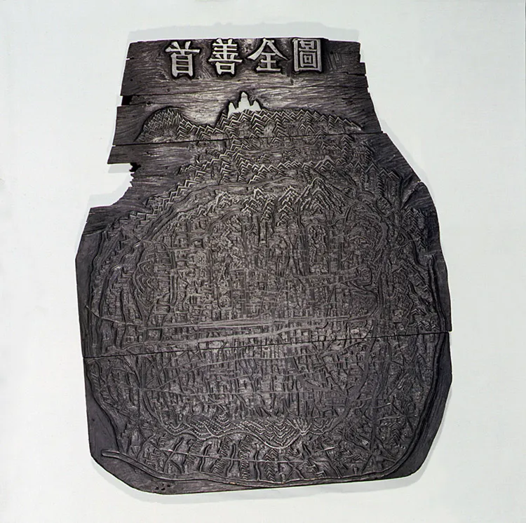
Suseon jeondo, the Comprehensive Map of the Capital, was produced by Kim Jeong-ho between 1824 and 1834. Measuring 82.5 cm ¡¿ 67.5 cm, it has been drawn precisely according to actual measurement. Suseon jeondo precisely depicts the Seoul area of the 1820s, with the main roads and facilities as well as the towns, mountains, and Buddhist temples outside the city walls depicted in detail. This is the most extraordinary example among the maps of Seoul at the time, considering its accuracy, precision, and size. With not only the map production but also the production skills of the printing woodblock assessed to be excellent, it has great value as a cultural heritage. The preservation state of the woodblock is very good.
Location
지도를 불러오는 중…
Have you visited this place?
Log in and verify your visit on-site via GPS to record a stamp in My Journey. (QR verification coming later.)
Images: KOGL (khs.go.kr) · Data source: Korea Heritage Service Open API (khs.go.kr)